

“Land & Sea, Bos as it was and never will be again…” *
A map of the western coastline of Bos
Westcoast of Bos represent!
Locations
Cities
Depicted are the major economical players in Bos, strung along the west coast.
In rough order from top to bottom, left to right, we see: Volxteen, Kaelte, Dynne, Oommers, Arys, Oonde, Rykdeur, Coudeheerd, Gonda, Oile, Vischburg, Neus, Aedelburcht, Worppe, Hakkelo, Vieroogen, Hoog-Soon, Wielewortel, Ankerlyck, Haltte, Keyskamp and Leeuye.
Regions
The regions, in bold lettering, are:
Pýktte, Flaumes, Scheldtland, Terppe, Zeeland, Holtezee and Dogge.
Explanation
The illustrated border is explained clockwise, from left-to-right:
I. Compass
(top left corner) In Bos maps habitually put the West on top, as dusk carries greater weight than dawn: this stems from the idea that if the Sun were never too rise again, at least it was witnessed one last time before it sank beneath the horizon.
II. Spruntte
This being collects its slime & snot in its mouth, and spews it out to fill the sea. Its shell siphons all the water again to start the cycle anew. he is pictured above the large island of Pýktte, a lush uninhabited island with only a handful of lumber camps -such as Volxteen) on its coast. Little is known of any previous inhabitants, but Spruntte is supposed to live in a large cave underneath it.
III. Bos
This map shows us the central westcoast of Bos, where land meets sea.
IV. Guddewoeled
Guddewoeled, the hairy wildman represents the Woeldevolxke (wildfolk, wildmen) who lives in the green thicket; he wields his club to crack nuts (and occasionally snails). They are believed to live on the most remote of islands, not depicted here.
V. Clouds of Dogge
Beneath the clouds lies the vast tidal island of Dogge, which barely reaches a few meters above sea-level. It is mostly uninhabited, save for a few seasonal fishing settlements. Nowhere in all of Bos are the shoals of fish so numerous and varied. Dogge lies under the sea level for the better part of each year, only surfacing during the summer months. When it is submerged, enormous cloud-masses form vaporous landscapes above it.
VI. Heetesonne & Dinsternisse
(top right corner) The Sun & Moon are known to smooch behind the cover of the clouds…
VII. Boodembeest
This tentacled beast of prodigious size causes the seas to ebb and flow with its constant thrashing. In reality these creatures are rare, and not very tasty.

The Weereldkraaker, archenemy of the Boodembeest.
VII. Frýsse
Caught in the tentacles is Frýsse, a quiet region that lies just beyond the border of this map. Next to it lies the Holtezee, the basin once known as Zwalpdal.
IX. Ringslang
This small ourobouros-style wurm is the artists’ hall-mark.
X. Zwithof
(bottom right corner) A representation of the Zwithof, home of Oorvent Fromagenet, the commisioner of this map.
XI. Saksse
The mountains and trees represent Saksse, where the Zwithof palace is located. Saksse lies far to the east beyond this mountain range.
XII. Brauec
The city where this document was drawn. Not pictured on the map.
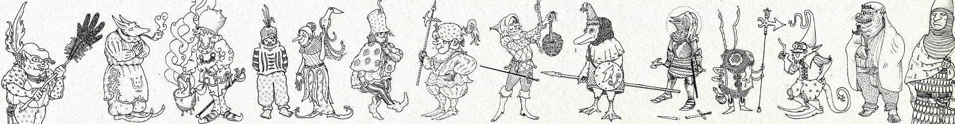
XIII. Gezanten
The 5 explorers/cartographers who contributed to this document.
XIV. Kratat
The city of Hartogh Ravýnnes Marktelaer, receiver of this map.
XV. Vrankke
The dominion of Kratat, it lies just beyond the border.
XVI. Grootmuyl
The Bigmouth fish, a classic of Bos iconography, its gluttonous character reminds the reader of the corruptions of power.


